Congestion Report 2020
Melbourne
 Note: Ratio of median travel time to best (shortest) travel time for each route.
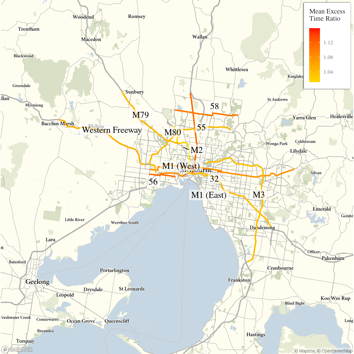
The figure below shows all 11 selected Melbourne freight vehicle routes and an index of the METR across each route.
The figure below shows changes in the METRs and MEURs across each of the 11 selected Melbourne freight vehicle routes travel time congestion reduced across almost all routes but particularly on the longer and freight-intensive M1 East, which services the CBD and industrial areas in Melbourne’s south east.
Unlike in Sydney, reduction in mean excess uncertainty was fairly systematic and correlated in some degree with mean excess time congestion, i.e. routes that experienced higher reductions in mean excess time also experienced reductions in mean excess travel time uncertainty.
Time congestion reduced across almost all routes but particularly on the lengthy and freight intensive M1 East servicing the CBD and industrial areas in the South East.

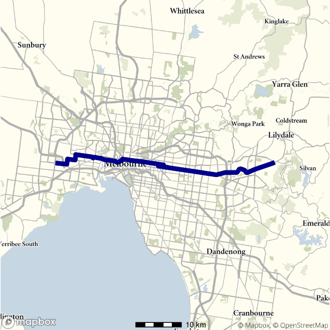
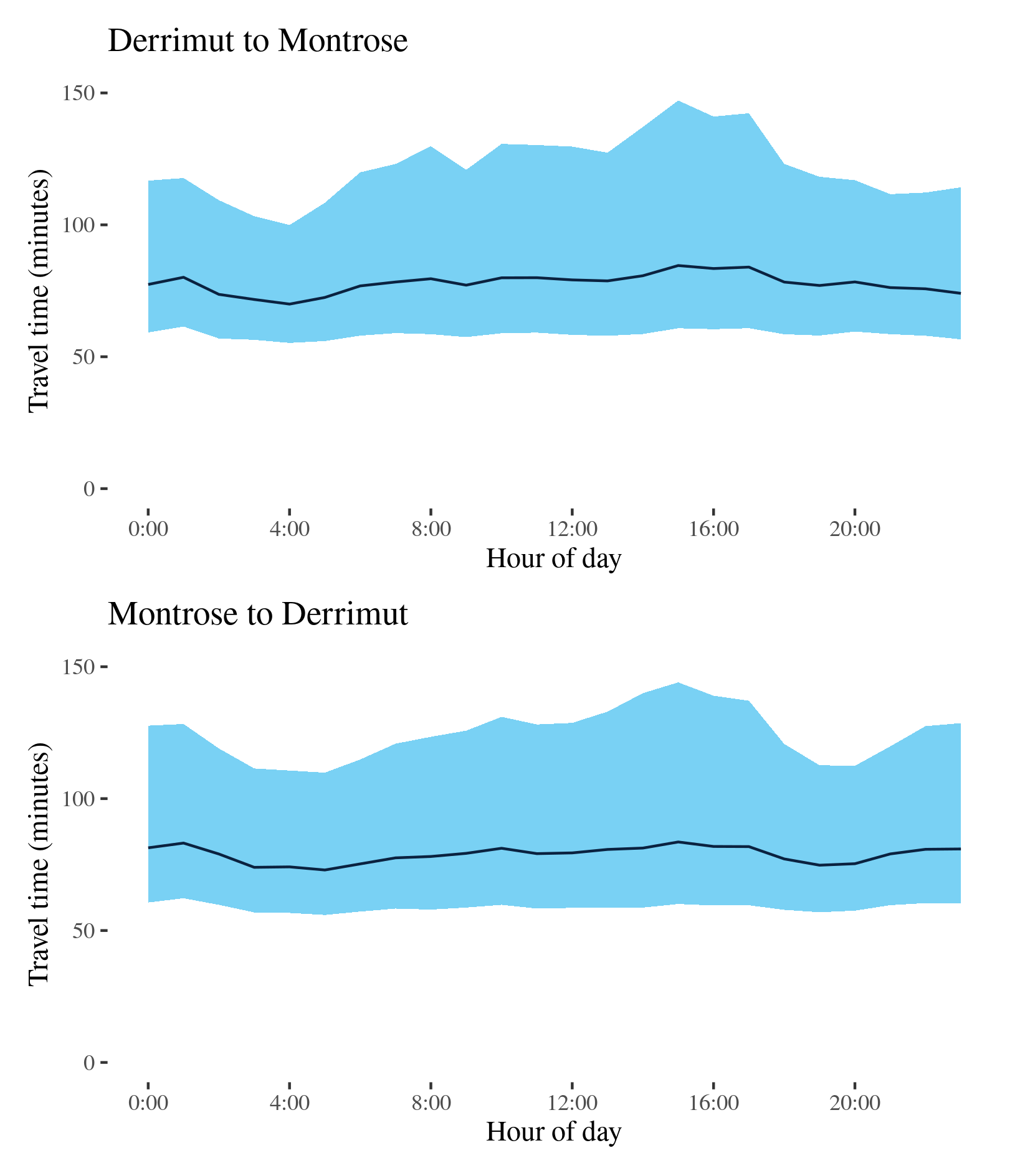
Route 32 - Derrimut to Montrose / Montrose to Derrimut
This surface route crosses Melbourne linking Derrimut in the West and Montrose in the east. Along its way, it crosses under the M80, passes Somerville Road, Footscray Road, Port of Melbourne and Victoria Street/Parade at Carlton, Burke Road in Camberwell, Canterbury Road, and intersects with the M3 at Ringwood.
| Direction | Best travel time | Longest median travel time | METR | Least uncertainty range | Most uncertainty range | MEUR | Distance |
|---|---|---|---|---|---|---|---|
| Derrimut to Montrose | 1:09:58 | 1:24:34 | 1.112 | 0:44:40 | 1:26:19 | 1.426 | 52.9 |
| Montrose to Derrimut | 1:12:57 | 1:23:34 | 1.08 | 0:53:57 | 1:24:01 | 1.224 | 53.1 |
The best median travel times and least uncertainty for journeys from Derrimut to Montrose were at 4am with a median travel time of 1 hour 10 minutes and an interquartile range of 45 minutes. The longest median travel times and greatest uncertainty were at 3pm with a median of 1 hour 25 minutes (a 9-minute improvement) and an interquartile range of 1 hour 26 minutes (a 151-minute improvement).
The best median travel time and least uncertainty for journeys from Montrose to Derrimut were at 5am with a median travel time of 1 hour 13 minutes and an interquartile range of 54 minutes. The longest median travel times and greatest uncertainty were at 3pm with a median of 1 hour 24 minutes and an interquartile range of 1 hour 24 minutes, significant improvements (14 minutes and one hour, respectively) on 2019.
The eastbound trip to Montrose and the westbound trip to Derrimut were similar in terms of travel time, travel time uncertainty and their patterns over the day. Elevated travel time and uncertainty were observed during business hours in both directions. There were no pronounced peaks in either direction but some signs of higher congestion around midnight. Delays were most noticeable around the CBD.
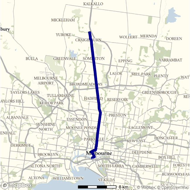
Route 55 - Hume Freeway to Montague St / Montague St to Hume Freeway
This surface route connects the Hume Freeway at Craigieburn and Montague Street in south Melbourne via Sydney Road through Somerton, Coburg and North Melbourne, skirting the CBD along Dudley Street and Wurundjeri Way.
| Direction | Best travel time | Longest median travel time | METR | Least uncertainty range | Most uncertainty range | MEUR | Distance |
|---|---|---|---|---|---|---|---|
| Hume Freeway to Montague St | 0:33:41 | 0:42:03 | 1.122 | 0:19:56 | 1:12:09 | 1.809 | 28.0 |
| Montague St to Hume Freeway | 0:34:51 | 0:44:22 | 1.114 | 0:19:46 | 1:02:21 | 1.808 | 28.0 |
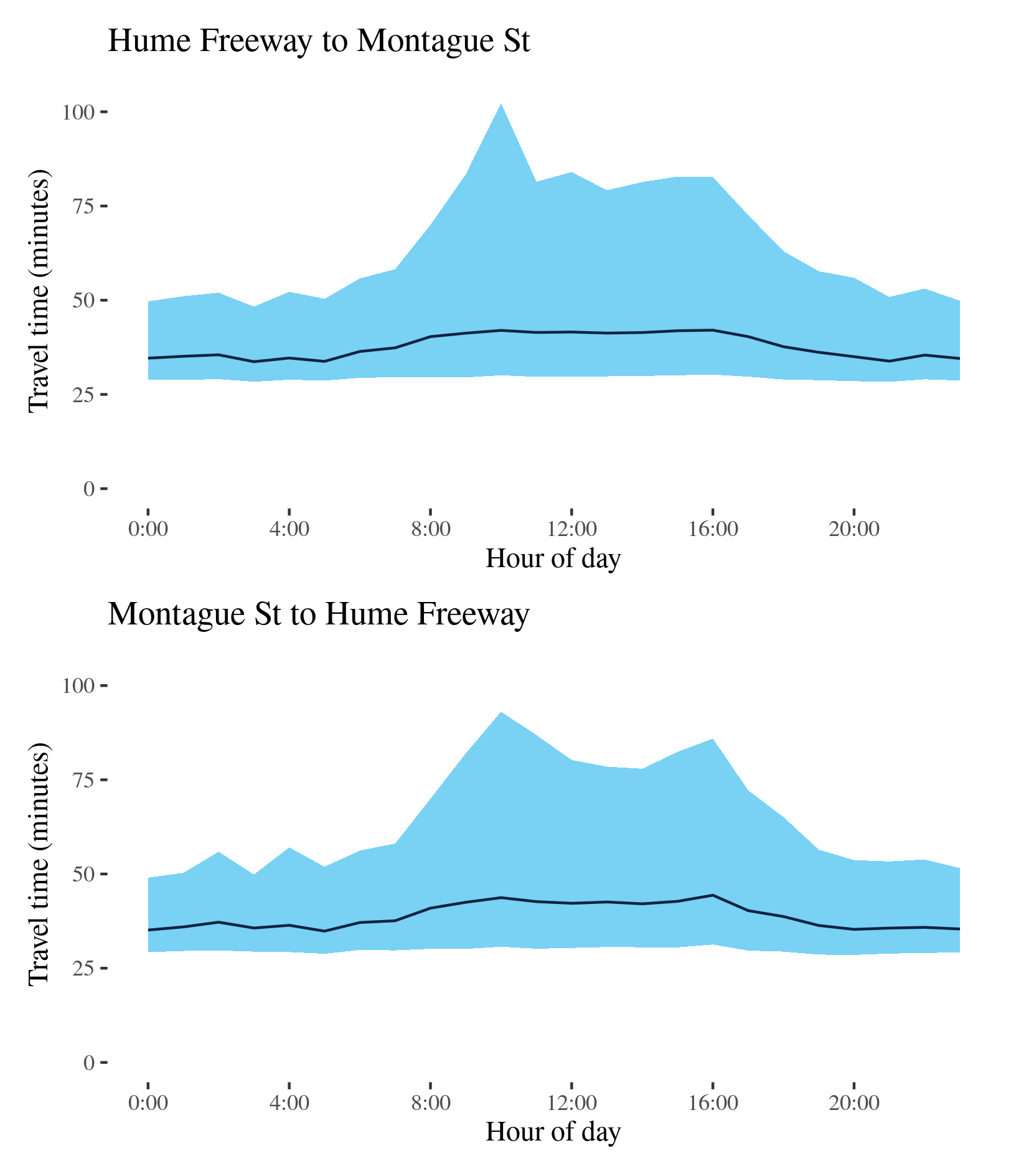
The best travel times and lowest uncertainty for journeys from the Hume Freeway to Montague Street were at 3am with a median travel time of 34 minutes and an interquartile range of 20 minutes. The longest median travel times were 42 minutes at 4pm and the greatest uncertainty were at 10 am with an interquartile range of 1 hour 12 minutes, a large improvement (11 minutes and over half an hour) on 2019. Delays were fairly evenly spread along the route but somewhat more apparent near the CBD and the M80 (Metropolitan Ring Road) at Broadmeadows.
The best median travel times for journeys from Montague Street to the Hume Freeway were 35 minutes at 5am and the lowest uncertainty was at midnight with an interquartile range of 20 minutes. The longest median travel times was 44 minutes at 4pm and the highest uncertainty were at 10am with an interquartile range of 1 hour 2 minutes (1 and 15 minutes down on 2019). Delays were spread fairly evenly throughout the route but slightly more apparent near south of Coburg.
Median travel times were similar in both directions throughout the day and uncertainty was also heightened throughout business hours, with distinct peaks in the morning.
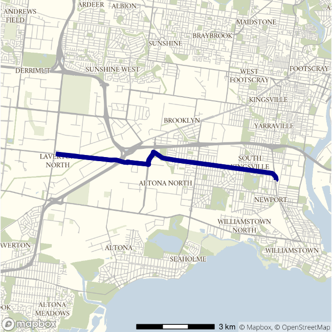
Route 56 - Laverton to Spotswood / Spotswood to Laverton
This surface route travels a short distance between Laverton and Spotswood in Melbourne’s West using Dohertys Road, Grieve Parade and Blackshaws Road and passes a number of light industrial areas.
| Direction | Best travel time | Longest median travel time | METR | Least uncertainty range | Most uncertainty range | MEUR | Distance |
|---|---|---|---|---|---|---|---|
| Laverton to Spotswood | 0:13:13 | 0:16:13 | 1.116 | 0:06:32 | 0:11:47 | 1.325 | 9.1 |
| Spotswood to Laverton | 0:13:27 | 0:16:56 | 1.112 | 0:07:10 | 0:14:43 | 1.4 | 9.1 |
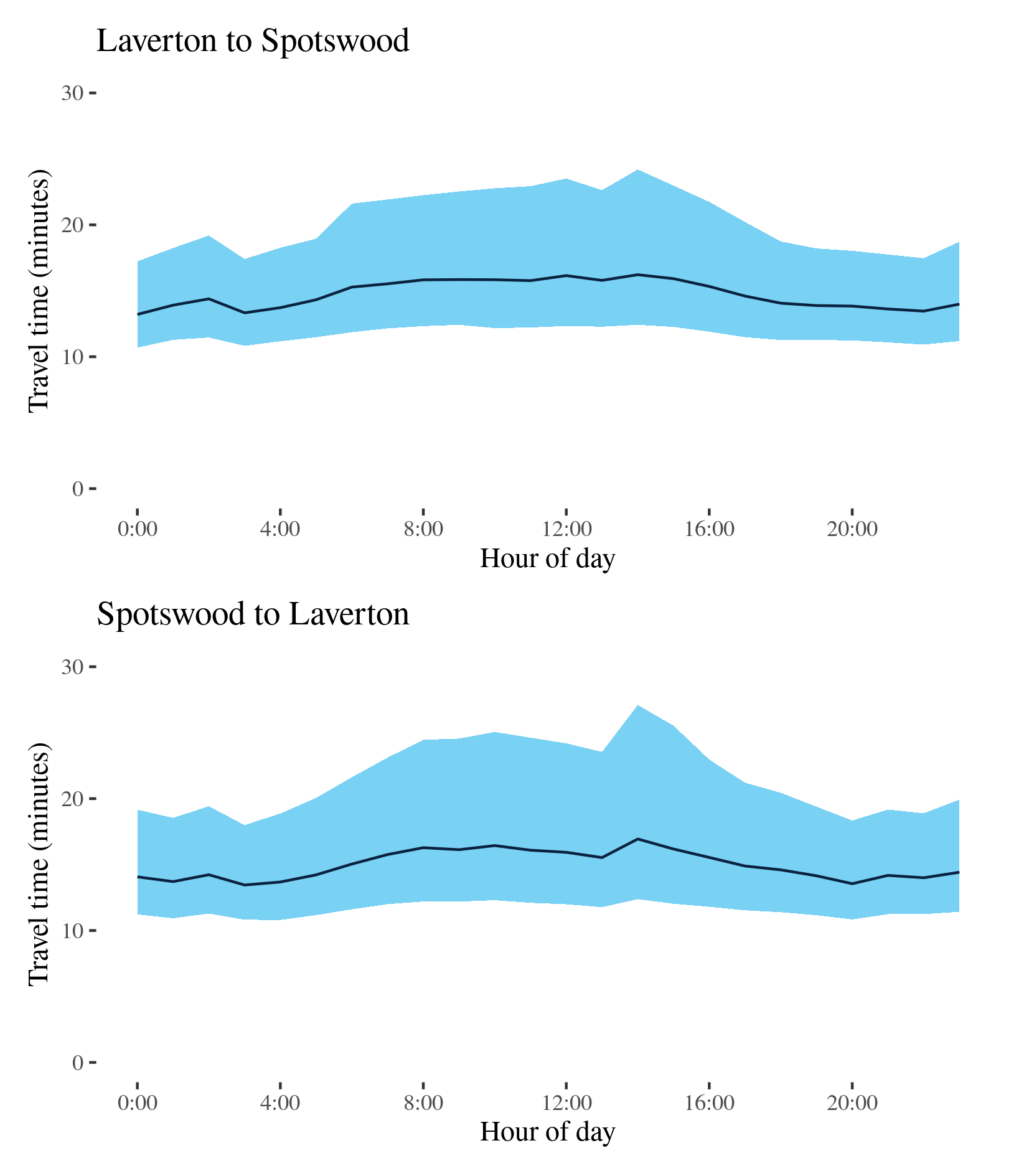
The best travel times and lowest uncertainty travelling from Laverton to Spotswood were at midnight with a median travel time of 13 minutes and an interquartile range of 6.5 minutes. The longest median travel times and greatest uncertainty were at 2pm with a median of 16 minutes and an interquartile range of 12 minutes, slightly longer than 2019. Delays were most apparent on Blackshaws Road in Altona North and through Laverton. Travel time and uncertainty were heightened throughout business hours.
The best travel times and lowest uncertainty travelling from Spotswood to Laverton were at 3am with a median travel time of 13 minutes and an interquartile range of 7 minutes. The longest median travel times and highest uncertainty were in the afternoon peak at 2pm with a median of 17 minutes and an interquartile range of 15 minutes, similar to 2019. Delays were fairly evenly spread along the route but were slightly more pronounced towards Laverton.
The “third peak” observed in 2019 was less apparent. This route otherwise saw little change from 2019, possibly due to relatively less commuter traffic compared to other routes.
Route 58 - Greenvale to Yan Yean Road / Yan Yean Road to Greenvale
This surface route crosses large part of Melbourne’s northern fringe connecting Mickleham Road in the west and the intersection of Gorge Road and Yan Yean Road near Plenty in the east. It uses Somerton Road, Cooper Street, High Street and McDonalds Road.
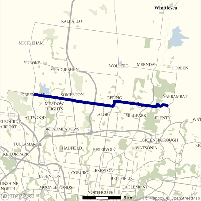
| Direction | Best travel time | Longest median travel time | METR | Least uncertainty range | Most uncertainty range | MEUR | Distance |
|---|---|---|---|---|---|---|---|
| Greenvale to Yan Yean Road | 0:26:00 | 0:34:11 | 1.098 | 0:13:53 | 0:32:45 | 1.42 | 22.6 |
| Yan Yean Road to Greenvale | 0:25:50 | 0:32:17 | 1.105 | 0:13:22 | 0:30:51 | 1.576 | 22.2 |
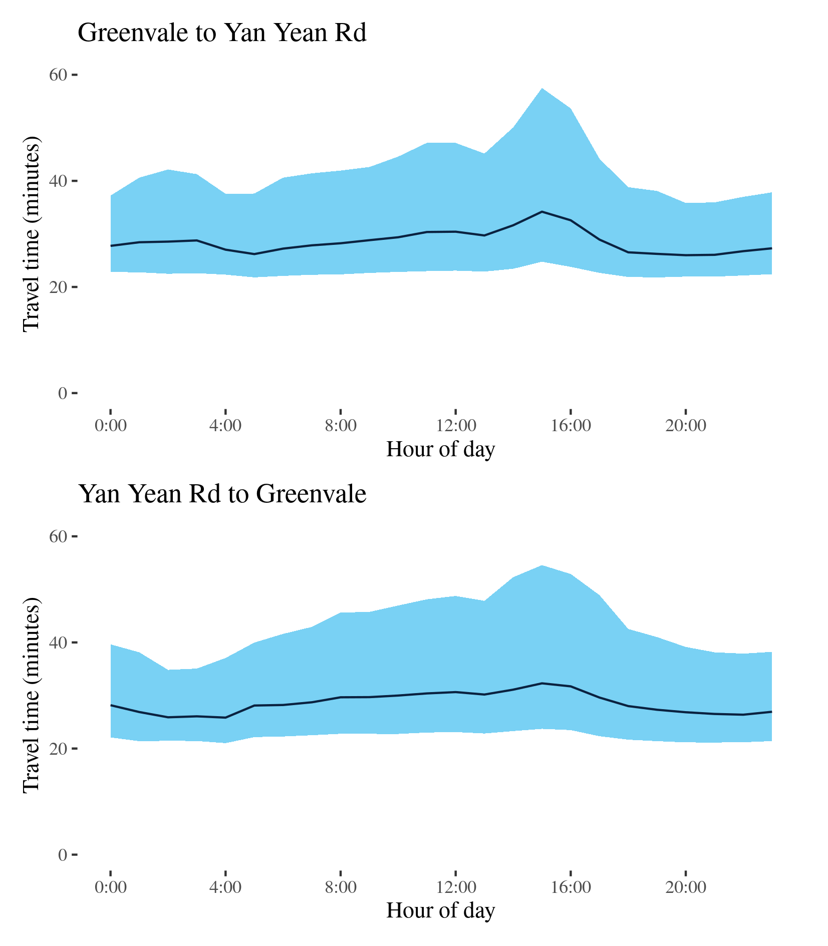
The best median travel time and lowest uncertainty travelling from Greenvale to Yan Yean Road were at 8pm with a median of 26 minutes and an interquartile range of 14 minutes. The longest median travel times and greatest uncertainty were in the afternoon peak at 3pm with a median of 34 minutes and an interquartile range of nearly 33 minute, down 1 and 5 minutes from 2019. Delays were spread evenly along the route but somewhat more apparent in High Street Epping.
The best median travel time travelling from Yan Yean Road to Greenvale were at 4am with a median of 26 minutes and the lowest uncertainty were at 2am with an interquartile range of 13 minutes. The longest median travel times and uncertainty were in the afternoon peak at 3pm with a median of 32 minutes and an interquartile range of 31 minutes, down 3 and 17 minutes from 2019. Delays were slightly more apparent near South Morang.
M1 (West) - City to M80 / M80 to City
This route follows the West Gate Freeway (M1) connecting at its confluence with the Western Ring Road (M80) at Altona and the M2 at south Melbourne. It serves extensive freight areas around Port Melbourne and in Melbourne’s west.
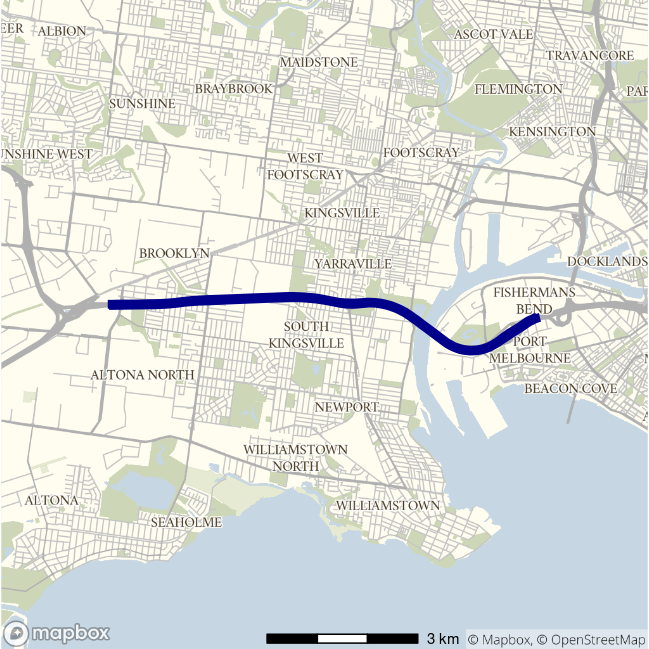
| Direction | Best travel time | Longest median travel time | METR | Least uncertainty range | Most uncertainty range | MEUR | Distance |
|---|---|---|---|---|---|---|---|
| City to M80 | 0:07:18 | 0:10:57 | 1.159 | 0:01:35 | 0:12:08 | 2.98 | 9.0 |
| M80 to City | 0:07:23 | 0:08:47 | 1.079 | 0:01:41 | 0:04:44 | 2.003 | 9.0 |
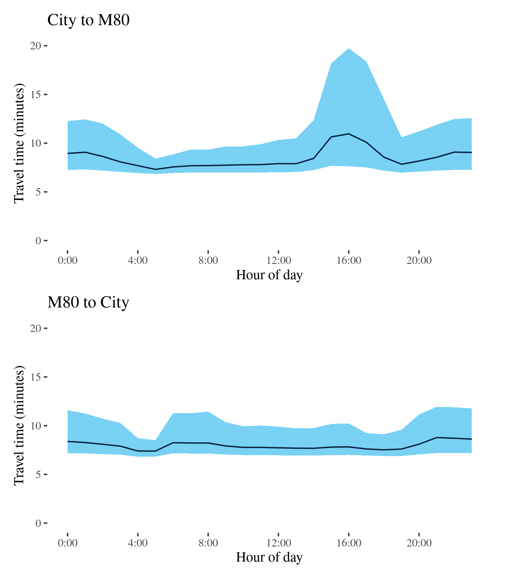
The best travel times and lowest uncertainty travelling from the City to the Western Ring Road (M80) were at 5am with a median travel time of 7 minutes and an interquartile range of 95 seconds. The longest median travel times and greatest uncertainty were in the afternoon peak at 4pm with a median of 11 minutes and an interquartile range of 12 minutes, improvements of 7 minutes in both cases. Delays were spread evenly along the route, but were most severe in Yarraville, rather than near Port Melbourne as in 2019.
The best median travel times and lowest uncertainty for journeys from the Western Ring Road (M80) to the CBD were at 5am with a median travel time of over 7 minutes and an interquartile range of 101 seconds. The longest median travel times and highest uncertainty were in evening at 9pm with a median of 9 minutes and an interquartile range of 5 minutes, down 5 and 11 minutes from 2019.
The CBD bound route retained its single morning peak of travel time and uncertainty, whereas the reverse trip, which had two peaks in 2019, in 2020 had no distinct peaks.
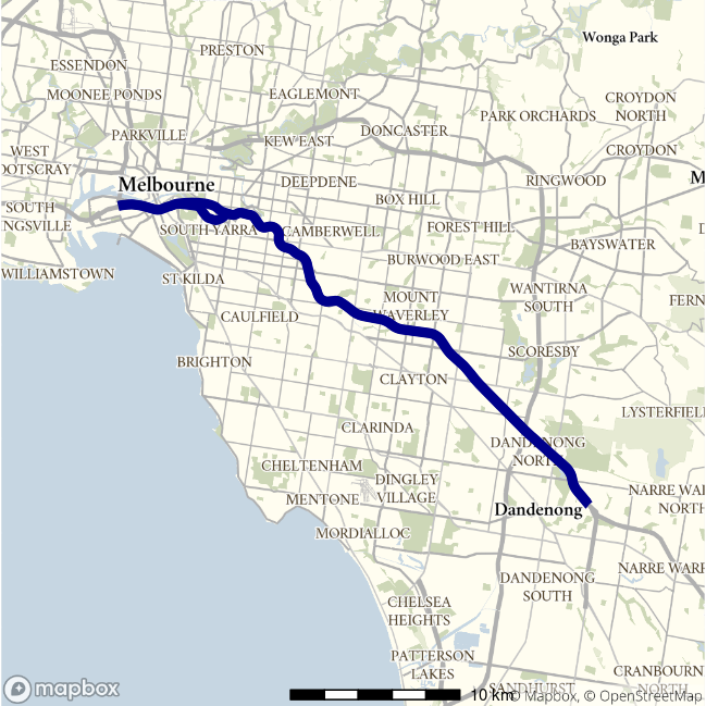
M1 (East) - City to M420 / M420 to City
This route follows the M1 connecting Port Melbourne and the South Gippsland Freeway (M420) on Melbourne’s fringes. It serves light industrial areas around Dandenong and interregional freight from Gippsland. For most of its length it is known as the Monash Freeway.
| Direction | Best travel time | Longest median travel time | METR | Least uncertainty range | Most uncertainty range | MEUR | Distance |
|---|---|---|---|---|---|---|---|
| City to M420 | 0:26:32 | 0:34:02 | 1.038 | 0:04:19 | 0:29:16 | 2.014 | 36.0 |
| M420 to City | 0:26:26 | 0:29:16 | 1.04 | 0:04:34 | 0:13:23 | 1.881 | 36.5 |
The best travel times and lowest uncertainty travelling from the CBD to Dandenong were at 5am with a median travel time of 27 minutes and an interquartile range of 4 minutes. The longest median travel times and greatest uncertainty were in the afternoon peak at 4pm with a median of 34 minutes and an interquartile range of 29, improvements of 25 and 43 minutes, respectively, from 2019, amongst the largest in this report. Delays were most apparent near Kooyong and Glen Iris and speeds largely improved closer to Dandenong, with the exception of delays around Burke Road in Camberwell.
The best travel times and lowest uncertainty travelling from Dandenong to the CBD were at 2 and 4am with a median travel time of 26 minutes and an interquartile range of 4.5 minutes. The longest median travel times were in the morning peak at 6am with a median of 29 minutes and the greatest uncertainty was at 5pm with an interquartile range of 13 minutes, improvements of 17 and 43 minutes from 2019. Distinct peaks in travel time were effectively eliminated while peaks in uncertainty reduced.
M2 - CityLink then Tullamarine / Tullamarine then CityLink
This route connects Melbourne Airport and the M1 at Port Melbourne via the CityLink toll road and Tullamarine Freeway.
| Direction | Best travel time | Longest median travel time | METR | Least uncertainty range | Most uncertainty range | MEUR | Distance |
|---|---|---|---|---|---|---|---|
| CityLink then Tullamarine | 0:14:42 | 0:15:18 | 1.02 | 0:01:28 | 0:04:51 | 1.676 | 19.8 |
| Tullamarine then CityLink | 0:14:30 | 0:14:54 | 1.012 | 0:01:13 | 0:03:04 | 1.611 | 19.8 |
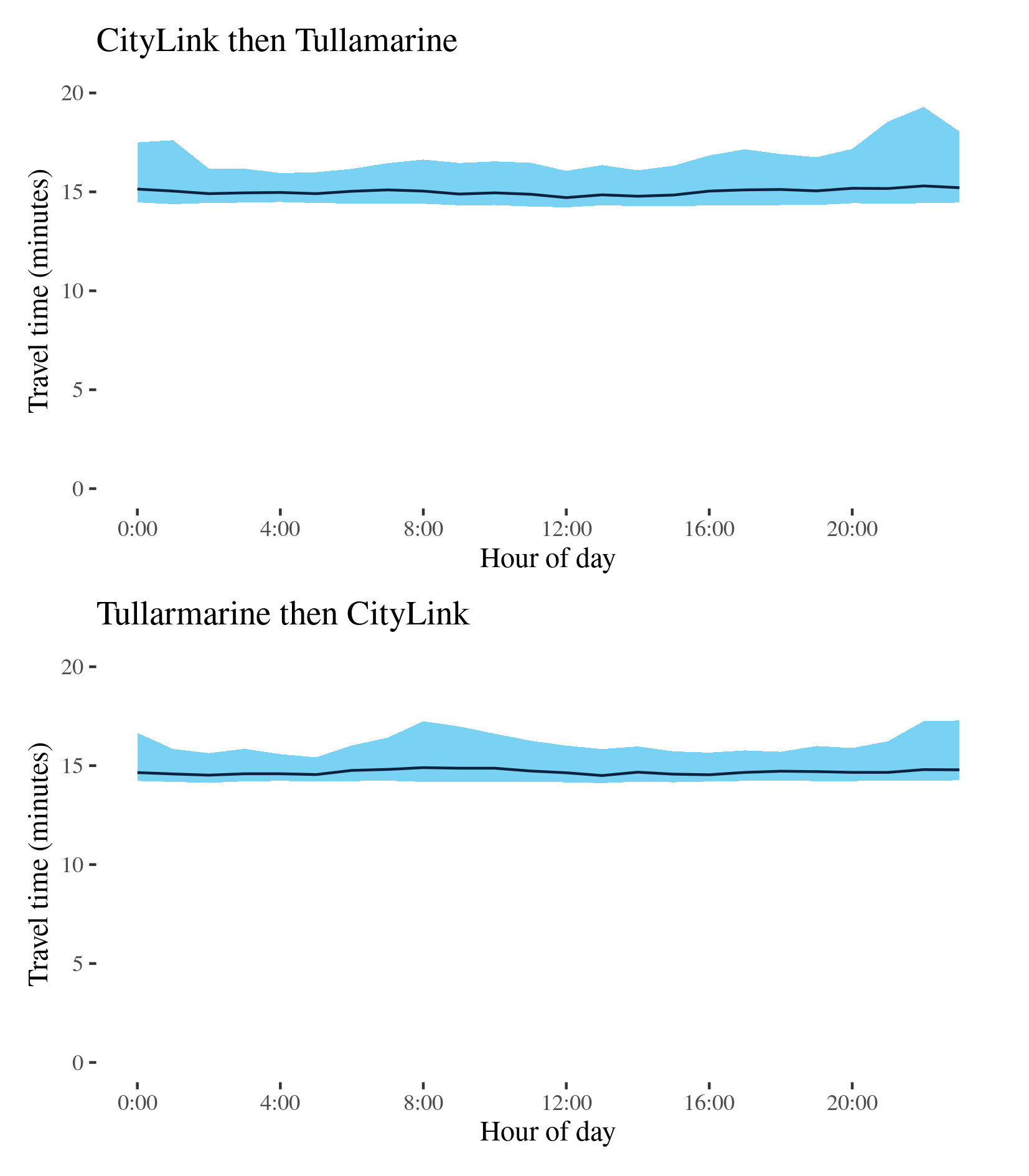
The best travel times and lowest uncertainty from the City to the Airport were at 4am and midday with a median travel time of 15 minutes and an interquartile range of 88 seconds respectively. The longest median travel times and greatest uncertainty were in the evening at 10pm with a median travel time of 15 minutes an interquartile range of 5 minutes. However, there were no distinct peaks or variation throughout the day.
The best travel times and lowest uncertainty from the Airport to the CBD were at 5am and 1pm with a median travel time of 14.5 minutes and an interquartile range of 73 seconds. The longest median travel times were in the morning peak at 8am, only 24 seconds longer than the best travel times. Uncertainty was greatest at 8am with an interquartile range of 3 minutes, a marked reduction from 2019 (6 minutes).
In both directions delays were most apparent close to the M1.
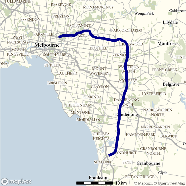
M3 - Frankston to Hoddle St / Hoddle St to Frankston
This route runs between Abbotsford and Frankston in Melbourne’s far south east. It uses the Eastern Freeway, Eastlink and the Frankston Freeway.
| Direction | Best travel time | Longest median travel time | METR | Least uncertainty range | Most uncertainty range | MEUR | Distance |
|---|---|---|---|---|---|---|---|
| Frankston to Hoddle St | 0:33:59 | 0:36:09 | 1.027 | 0:04:08 | 0:09:27 | 1.639 | 53.0 |
| Hoddle St to Frankston | 0:34:02 | 0:41:13 | 1.037 | 0:04:32 | 0:27:11 | 1.869 | 53.3 |
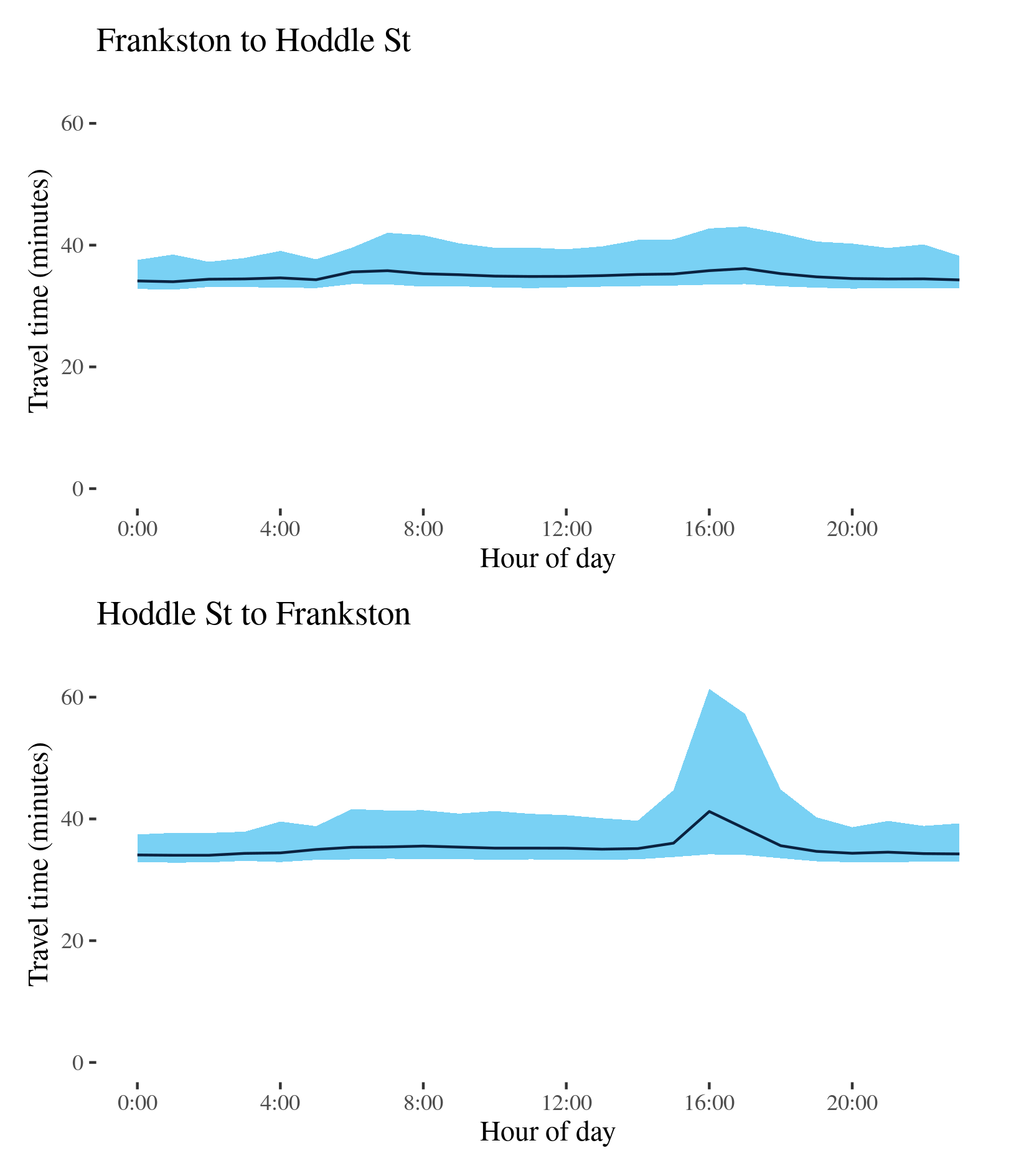
The best median travel times travelling from Frankston to Hoddle Street were 34 minutes at 1am and the lowest uncertainty were 2am with an interquartile range of 4 minutes. The longest median travel times and greatest uncertainty were in the afternoon at 5pm with a median of 36 minutes and an interquartile range of over 9 minutes, down 10 and 18 minutes on 2019. The morning peak evident in 2019 was eliminated. Delays were most severe near the Melba tunnel at Ringwood but delays near the city were no longer apparent.
The best travel times and lowest uncertainty travelling to Frankston were at 1am and midnight with a median travel time of 34 minutes and an interquartile range of 4.5 minutes. The longest median travel times and highest uncertainty were in the afternoon peak at 4pm with a median of 41 minutes and an interquartile range of 27 minutes, down 10 and 4 minutes on 2019. The afternoon peak was still apparent but reduced. Delays were most severe on the Eastern Freeway.
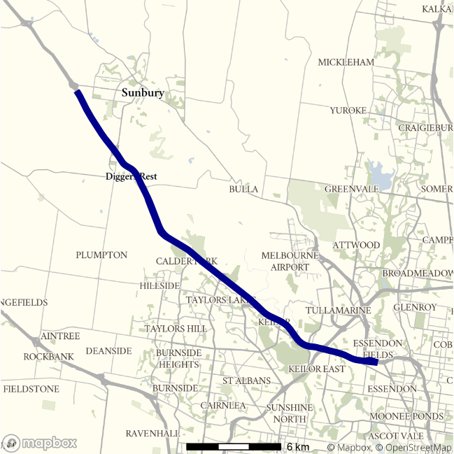
M79 - Essendon to Gap Road / Gap Road to Essendon
This lengthy motorway route follows the A79/M79 from Gap Road, west of Sunbury, to Essendon where it joins the CityLink toll road. For most of its length it is known as the Calder Freeway.
| Direction | Best travel time | Longest median travel time | METR | Least uncertainty range | Most uncertainty range | MEUR | Distance |
|---|---|---|---|---|---|---|---|
| Essendon to Gap Road | 0:18:41 | 0:19:47 | 1.024 | 0:01:57 | 0:06:51 | 1.677 | 27.3 |
| Gap Road to Essendon | 0:17:00 | 0:18:10 | 1.045 | 0:01:43 | 0:05:00 | 1.677 | 27.2 |
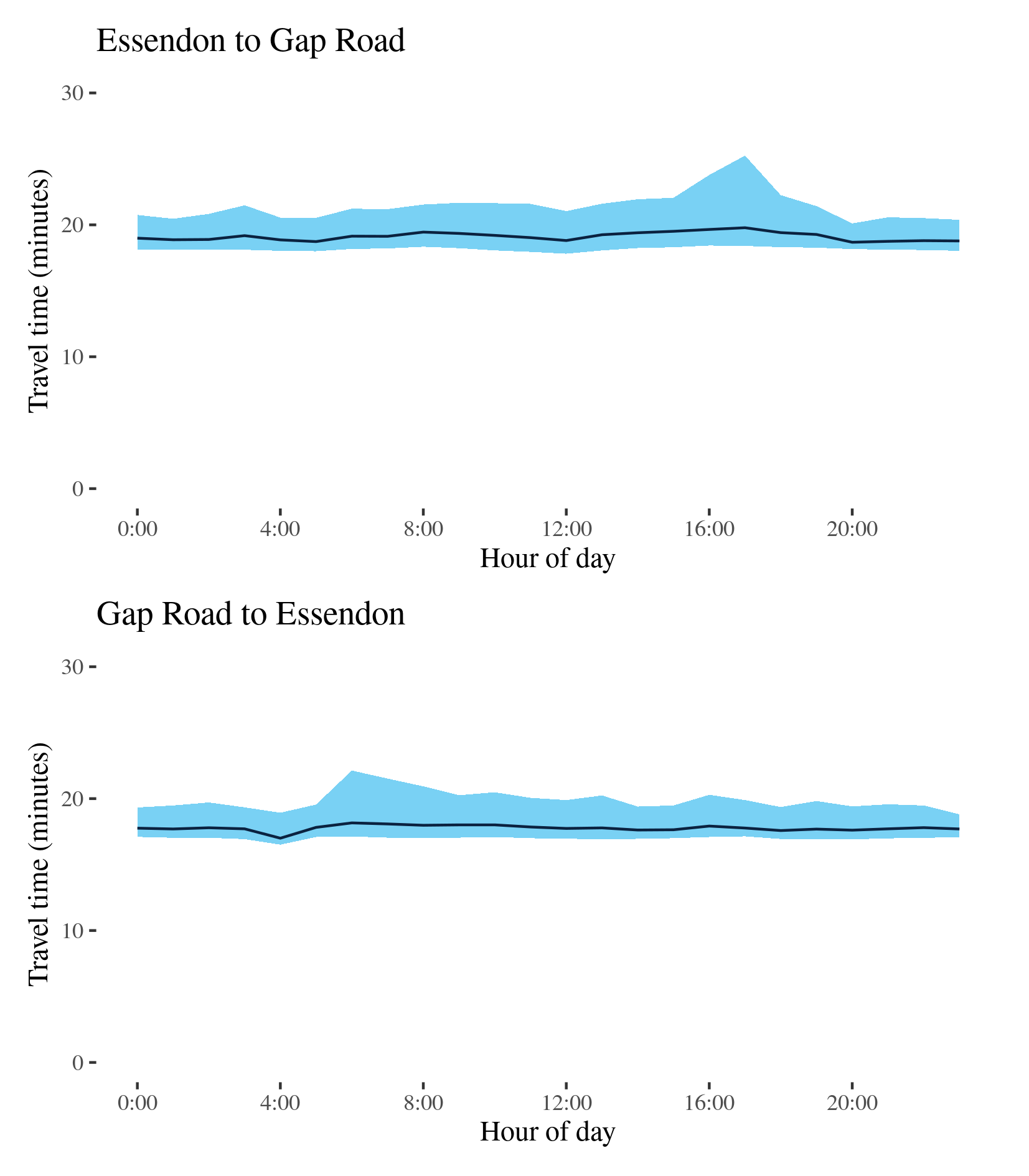
The best median travel times and lowest uncertainty from Essendon to Gap Road were at 8pm with 19 minutes and an interquartile range of 2 minutes. The longest median travel times and highest uncertainty were in the afternoon peak at 5pm with a median of 20 minutes and an interquartile range of 7 minutes, down 3 and 6 minutes, respectively, from 2019. The afternoon peak was effectively eliminated.
The best travel times and lowest uncertainty travelling from Gap Road to Essendon were at 4am and 11pm with a median travel time of 17 minutes and an interquartile range of 103 seconds. The longest median travel times and greatest uncertainty were at 6am with a median of 18 minutes and an interquartile range of 5 minutes, down 1.5 and 3 minutes, respectively, on 2019. The morning peak was milder than 2019. Delays were most evident near the end of the motorway near the intersection with the Western Ring Road.
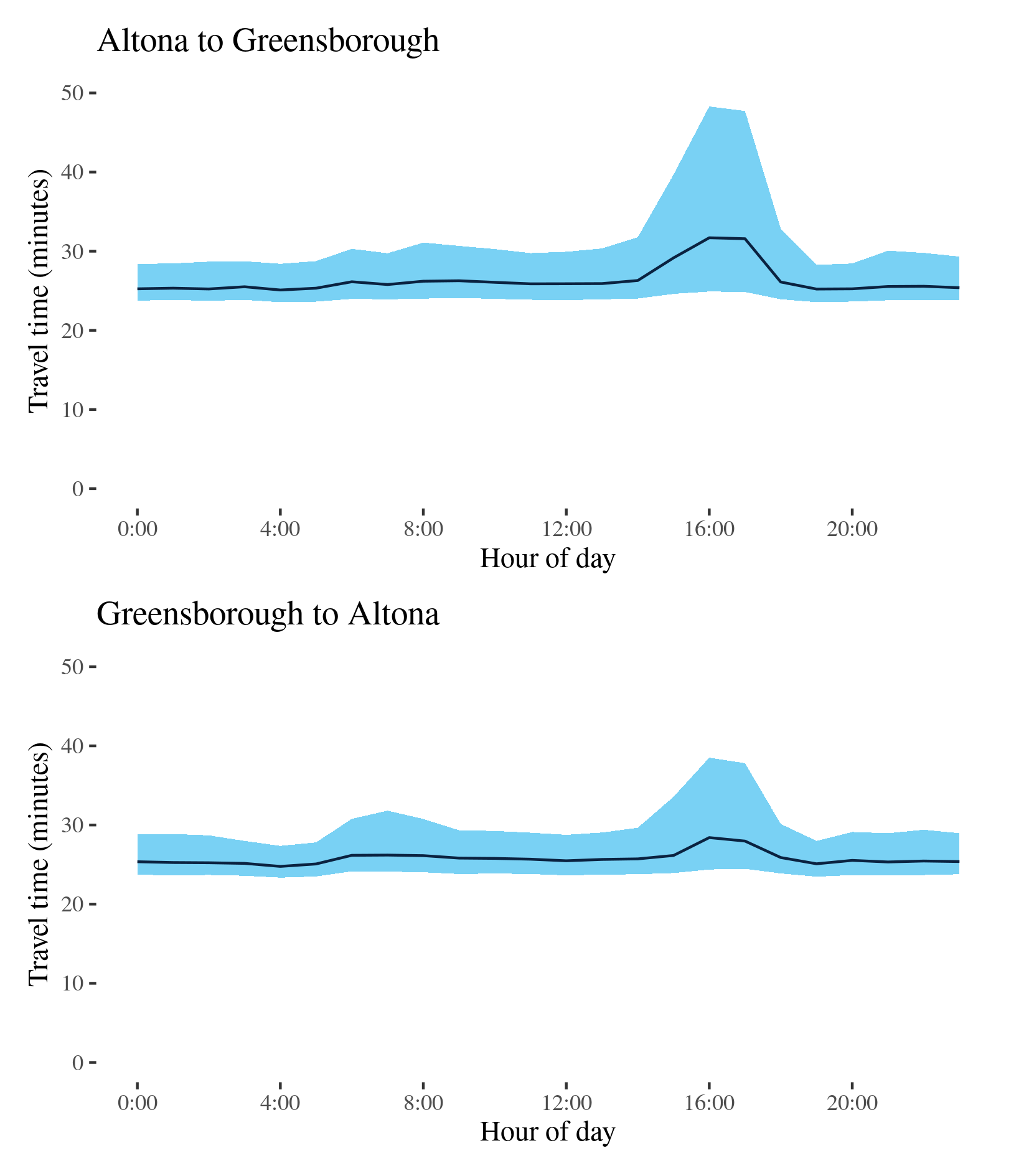
M80 - Altona to Greensborough / Greensborough to Altona
This route follows the M80 (Western Ring Road) in the west and north of Melbourne. It passes through the western outskirts of the Melbourne metropolitan area as the Western Ring Road, meets the M1 and proceeds to the Greensborough Bypass in north-east Melbourne as the Metropolitan Ring Road.
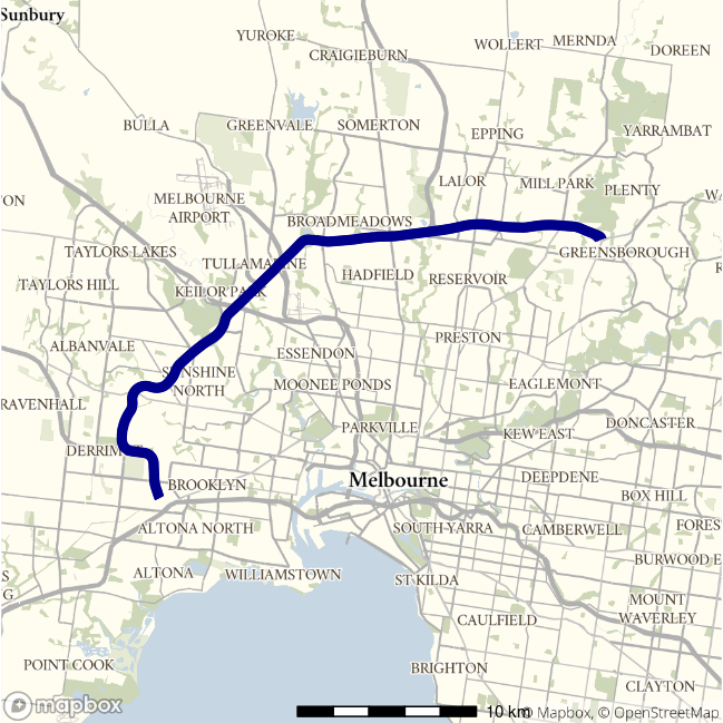
| Direction | Best travel time | Longest median travel time | METR | Least uncertainty range | Most uncertainty range | MEUR | Distance |
|---|---|---|---|---|---|---|---|
| Altona to Greensborough | 0:25:06 | 0:31:42 | 1.049 | 0:04:37 | 0:23:23 | 1.667 | 37.5 |
| Greensborough to Altona | 0:24:46 | 0:28:25 | 1.041 | 0:04:01 | 0:14:08 | 1.569 | 37.4 |
The best travel times and lowest uncertainty for trips from Altona to Greensborough were at 4 and 1am with a median travel time of 25 minutes and an interquartile range of 4.5 minutes. The longest median travel times and greatest uncertainty were in the afternoon peak at 4pm with a median of 32 minutes and an interquartile range of 23 minutes, a reduction of 10 and 7 minutes, respectively on 2019. Delays were most evident near the end of the motorway at Bundoora with indications of delays near the intersections with the Westlink and Tullamarine Freeways. There was a mild morning peak with delays near Greensborough that was evident in 2019 but not in 2020.
The best travel times and lowest uncertainty for trips from Greensborough to Altona were at 4am with a median of 25 minutes and an interquartile range of 4 minutes. The longest median travel times and highest uncertainty were in the afternoon peak at 4pm with a median of 28 minutes and an interquartile range of 14 minutes, down 2 and 8 minutes, respectively, on 2019. The morning peak was effectively eliminated. Delays were most evident near the M8 (Western Freeway) at Derrimut.
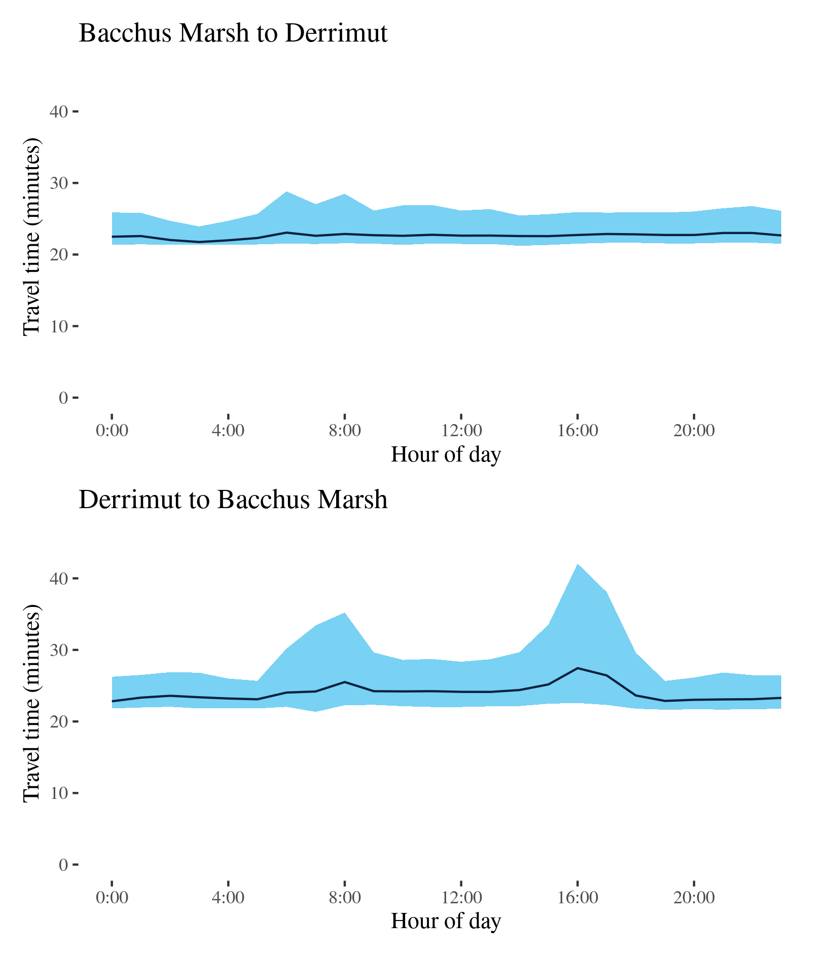
Western Freeway - Bacchus Marsh to Derrimut / Derrimut to Bacchus Marsh
This route follows the Western Freeway (M8) linking Bacchus Marsh west of Melbourne and Derrimut where it meets the M80 (Western Ring Road).
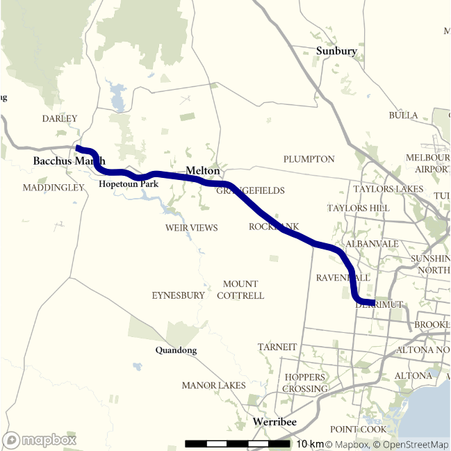
| Direction | Best travel time | Longest median travel time | METR | Least uncertainty range | Most uncertainty range | MEUR | Distance |
|---|---|---|---|---|---|---|---|
| Bacchus Marsh to Derrimut | 0:21:45 | 0:23:04 | 1.04 | 0:02:35 | 0:07:18 | 1.807 | 35.7 |
| Derrimut to Bacchus Marsh | 0:22:49 | 0:27:27 | 1.053 | 0:03:52 | 0:19:29 | 1.922 | 35.6 |
The best travel times and lowest uncertainty travelling from Bacchus Marsh to Derrimut were at 3am with a median travel time of 22 minutes and an interquartile range of 2.5 minutes. The longest median travel times and greatest uncertainty were in the morning peak at 6am with a median of 23 minutes and an interquartile range of 7 minutes, similar to 2019. There is evidence of mild delays at Melton.
The best median travel times travelling from Derrimut to Bacchus Marsh were 23 minutes at midnight and the lowest uncertainty were at 5am with an interquartile range of 4 minutes. The longest median travel times and highest uncertainty were in the afternoon peak at 4pm with a median of 27 minutes and an interquartile range of 19 minutes, also similar to 2019. This peak was more pronounced than the increase in travel time uncertainty between 6 and 9am in the reverse direction and delays were concentrated close to where the motorway meets the Old Western Highway.
Overall this route displayed little change from 2019.